Towards the end of summer in 2017, I was really getting antsy to go on a trip to South Dakota with my camera gear and explore The Great Plains. This idea came about because while a good portion of my family is from the South Dakota area, I had become familiar with certain areas of the state over the years, but not others. Up until I was eighteen, I traveled to South Dakota twice a year every year with my family to visit our relatives. Subsequent years, I was lucky to make a single trip due to work and/or school. The time came for me to explore the area more on my terms.
Ironically enough, around the same time, my good friend, Rick, was looking to check out the western region of South Dakota and Wyoming for some possible JEEP off-roading opportunities. We decided to collaborate and a five-day trip grew to fruition. We would drive out to eastern South Dakota in one day, and then each day after, journey a little farther west with planned destinations to scope out. Some of these were typical sightseeing opportunities and others were off the beaten path a little bit.
The nine-hour drive out to eastern South Dakota was met with rain and wind. Lots of wind. The thing about riding in a boxy car that is driving straight into a rainy headwind is it is nearly impossible to hear music on the radio or have a conversation without yelling. The majority of this leg of the journey wasn’t captured due to weather conditions. However we did stop and take some photos at the Jolly Green Giant statue in Blue Earth, Minnesota and see the Sioux Falls in Sioux Falls, South Dakota.


Day two started off early with a trek out to my Grandfather’s land to explore where he spent a good portion of his life farming. We took a few unmaintained roads through some fields and also managed to run into some friends of my family. It was a great way to start off the trip because I was able to get some time in with the drone and take my time with setting up some ideas for shots. Before we knew it, it was noon and it was time to head towards Pierre, South Dakota.

One thing you’ll notice as you make your way west from eastern South Dakota is the flatness of the country starts to grow into more rolling hills. Don’t get me wrong, it’s still very flat compared to the Black Hills, but the change in landscape is quite noticeable. The wind once again was quite loud during this leg of the trip. I began this game where we would drive by fields of cattle and I would try to film Rick “eating” cattle as we passed by (think Pac-Man). You can see a couple GIFs of this within the mix of photographs. Once in Pierre, we stopped by the Capitol and grabbed lunch at a local sports bar. Our goal for the day was to make it through the Badlands before it got dark.


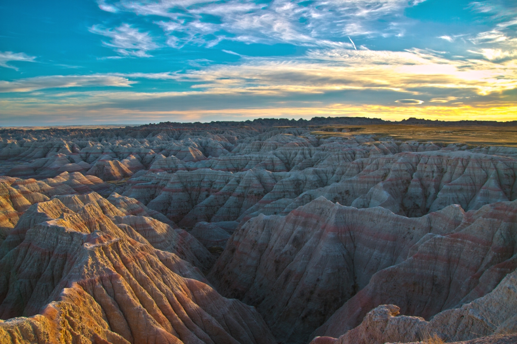
We spent quite a bit more time in the Badlands than we first thought we would. This was mostly my doing. After a gorgeous drive during sunset through the National Park, I wanted to stick around and shoot some stars under a sky without light pollution. If you haven’t been to the park, I highly recommend it. We eventually ended up in Rapid City for the night and prepared for a busy day three.


We woke up early day three to head out from Rapid City and check out Bear Butte just northeast of Sturgis, South Dakota. We opted to take the drive through the Black Hills as opposed to Highway 90 just so we could see as much of the National Forest as possible. Very scenic area and frankly one of my favorite drives of the trip. We made a quick stop near Bear Butte for a time-lapse and trekked southwest to Deadwood to visit the historic gold rush town. We encountered a large group of the local wildlife at the gas station in town and got a selfie with a Wild Bill Hickok impersonator. After having a beer at the bar that featured the chair Wild Bill died in and a show that acted out his death every couple of hours, we left town to head to Lead, South Dakota. In Lead there is an old gold mine that has a scientific lab deep underground. This lab is called the Sanford Underground Research Facility. At the visitor center (above ground) they let you launch golf balls into the abandoned gold mine. This was just the first leg of day three.


Upon leaving Lead, we made our journey to Devils Tower in Wyoming (only 77 miles away). This was going to be our only planned stop in Wyoming, and we were close enough to where we decided to just go for it while we had light. I can’t remember which highway we took to get there. I just remember driving down this steep road where a semi was having trouble making it up, coming around a corner, and seeing Devils Tower out in the distance. We pulled over at this point to set up my camera and my Timelapse+ VIEW. The rest of the drive to the National Monument was great as we got closer and closer to the giant pillar sticking out of the earth. There is an area designated for prairie dogs right as you pull into the grounds and binoculars stationed throughout the area so you can get a close look at the individuals climbing the tower. We hiked around Devils Tower and were getting ready to leave when we ran into one of the climbers who had finished his climb and was heading back to his vehicle. Apparently the top of Devils Tower is a hill, and it has grass and wildlife as well.


We woke up really early on day four to head from Rapid City to spend a day in the Black Hills National Forest. We found a DNR building where we were able to get trail guides for off-roading, and we set out to check out a few stops along the way. We wanted to check out Mount Coolidge due to the expansive views it offered and the scary drive I read about online, but they were closed for the season. After discovering Mount Coolidge was closed, we drove around aimlessly in the hills for a while finding some trials to go on and spots to check out along the way as we made our way to the Needles Highway (SD 87). The Needles Highway is a very scenic drive through the Black Hills which they close in the winter because it is so mountainous and curvy. Towards the highest altitude of the drive, there are rocky spires that come out of the ground. I am guessing this is what inspired the name “Needles Highway.” After finishing the route, Rick and I were pretty exhausted from being on the go constantly the past couple of days. We took the opportunity to set up our campsite out by Sheridan Lake in the Black Hills a little bit early and relaxed a bit before our long drive back to Wisconsin the next day. It was quite a windy night, but there was no rain in the forecast. I finally had a great opportunity to set up a day to night to day time-lapse with my Timelapse+ VIEW and a larger external camera battery. I’ll get into shooting day to night to day time-lapses in another post though. The next morning we packed up our campsite and headed back to Wisconsin.


